Freitag, 31. August 2018

141

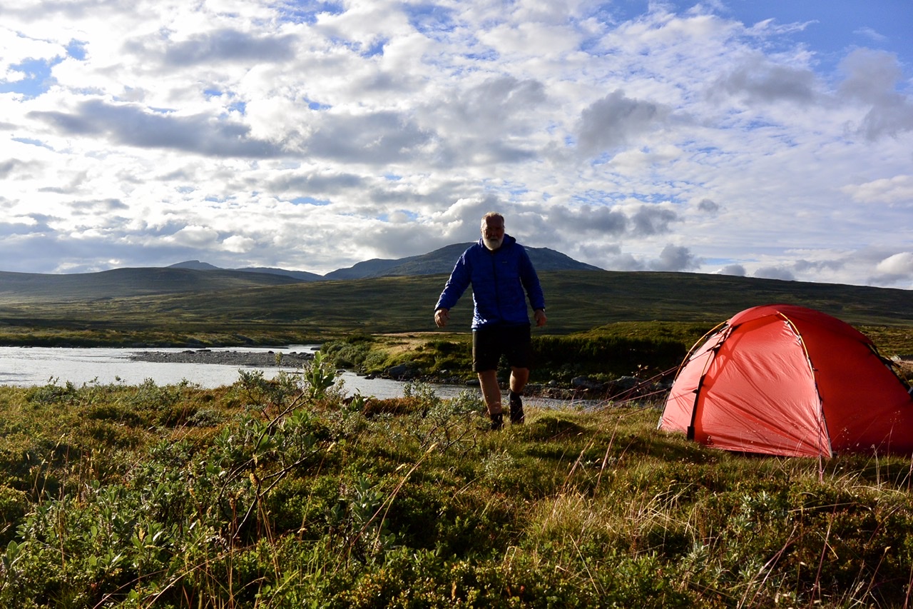
Day 56  gröna bandet 1093.19 ☀️
From Kvikkjokk via STF Pårte 

Pos   N 67 04 991  E 18 03 935
Loc   Camp i fjällen, near bridge  817 m
Acc  Soulo
Dis    25.2 km
Sta   09.15
End  19.45
Tim   10.30


Donnerstag, 30. August 2018

140

Mein Geburtstagsgeschenk 

☀️ Morgen ganztags Sonne! ☀️ 

139

My equipment - Spot Gen 3

Ich habe den Eindruck, dass das Spot Gen 3 nicht immer zuverlässig arbeitet. Wenn ich selbst online bin, kann ich leicht kontrollieren, ob die Email mit dem Standort rausgegangen ist. Wenn ich offline bin, habe ich keine Möglichkeit dazu, kann das Gerät nur 30 Min senden lassen. Muss mich dann darauf verlassen, dass die Meldung geschickt wurde. Dies ist leider nicht immer der Fall, wie ich im Nachhinein zwei Mal feststellen musste.
Was bleibt? In solchen Fällen (wenn offline) am selben Tag und/oder am Folgetag eine Position während der halbstündigen Mittagspause rausschicken! Das wird jetzt in den kommenden drei Wochen häufiger der Fall sein. 

138

Day 55 🌧 6-12  S 4-5 m/s
Zero day 

Loc   Kvikkjokk Fjällstation
Acc   Room

Mittwoch, 29. August 2018

137

Day 54  gröna bandet 1067.99 ☁️ 

Pos   N 66 57 144   E 17 43 111
Loc   Kvikkjokk Fjällstation
Acc   Matratzenlager
Dis    28.68
Sta   08.45
End  18.45
Tim   10.00

Boat Transfer
Dis   03.75
Sta  19.00
End 19.30


Dienstag, 28. August
Day 53  gröna bandet 1039.31 🌧☁️ 5-13  W 2-3 m/


Pos   N 66 45 291   E 17 24 886
Loc    Camp i fjällen / skogen  560m
Acc   Soulo
Dis    17.78
Sta   12.00
End  19.20
Tim   07.20

People on the trail - Helen
I woke up in the clouds. A misty morning. Tent all wet! Took my time to separate inner from outer tent to keep it dry and started late. Visibility low. I came down from the fjell heading for Piteälven. Just above the tree line two Swedish women going the opposite direction enjoyed the view across the land and the lakes. It was a magic spot indeed, clouds lifting, creating a meditative atmosphere. 
Helen, the older one, talked to me in German, had spent years in Germany. Later we switched to English, her company didn’t speak German.
Helen, younger than me, but at an age when you care about the fundamentals, the essentials  of life, had a talent to bridge the distance of strangers with the warm compassion of close companions. Talking about ‘lap* sjuka’, the feeling of loneliness and homesickness, she simply asked: ‘How many hugs did you have during the last days?’ ‘None’, I said, ‘someone understands a lonely hikers’ soul.’ We shared a hug and the world felt different that day!
Helen, you made my day! 

* The people refered to call themselves Sami, so all words containing lap like ‘lapland’ etc. might not be considered politically correct, but seem to be difficult to change. 

Fifty ways to ... stumble, slip and fall ...
It’s indeed fairly easy to loose balance while hiking, a heavy backpack can be difficult to control. Beware of heel hooks and toe loops, there are roots and rocks to stumble over,  muddy slopes, or slippery planks, all kinds of obstacles... but this fall was very special and unique! 
I had given my camera to Helen to take a photo. Thinking she was a bit close I took a single step back. That was a minor mistake, because the level of ground was a little lower. So, to regain balance - the backpack still on my back - I stepped back with the other foot. That was a major mistake - no ground. I fell right backwards on my backpack. Rather soft and cushioned feeling, I thought, completed the roll back and ended up lying on my side missing the rocks on both sides. Okay. No helicopter! Got away with it! Nothing hurt! 'Did you take the picture? No? Sorry, but I won’t do this stunt another time!'

Montag, 27. August 2018

136

Day 52  gröna bandet 1021.53☀️🌤 5-13  W 2-3 m/s

Pos    N 66 39 000   E 17 15 612
Loc    Camp i fjällen; near Tjaurakåtan 881 m
Acc    Soulo
Dis    20.39 km
Sta   10.00
End  18.45
Tim   08.45 hrs

Heute überquerte ich den nördlichen Polarkreis, an einem völlig unspektakulären Ort mitten im Birkenwald. Das leicht zu übersehende Schild deckte sich mit meiner GPS Karte, allerdings nicht mit den Daten N 66 33 55. 
https://de.m.wikipedia.org/wiki/Polarkreis

Kurze Zeit später habe ich endlich die Baumgrenze erreicht und vier Stunden schwierigen, steinigen Wegs liegen hinter mir. An einem Bach lege ich eine kurze Pause ein. Die Sonne scheint, ein paar weiße Wolken am Himmel. Rentiere blicken über den Kamm. Ein Adler überfliegt das Fjäll und ist schnell wieder außer Sicht. Wunderschön hier oben! (foto) 

Es wird langsam Herbst 🍂 im Fjäll ... Vor einigen Tagen fiel der erste Neuschnee auf dem Sytertoppen, manche Nächte waren schon bitterkalt. Auffliegende Schneehühner im Wechsel von Sommer- auf Winterkleid zeigen bereits viele weiße Federn. Es gibt kaum noch Mücken. Gräser und Farne färben sich leuchtend gelb, die Blätter der Zwergbirken wechseln von grün zu gelb und orange-rot. Ebereschen erscheinen zweifarbig, ein Zweig rot, der andere grün. Das Laub der Heidelbeeren taucht ganze Flächen in ein flammendes Rot. Das Spiel der Farben im 'Indian summer' hat hier im Norden eine unglaubliche Leuchtkraft und die Natur verabschiedet sich in einem Rausch von Farben.  'Fjällen brinner' sagen die Schweden, 'The Mountains are burning'
Ich bin froh und sehr, sehr dankbar, dass ich diesen Weg im Herbst meines Lebens gehen kann. Ich feiere die Farben, die überwältigende Landschaft und Natur, das Dasein, und genieße es auf dem letztlich endlichen Pfad unterwegs zu sein! Drei Wochen werde ich wohl noch brauchen. 


Sonntag, 26. August 2018

135

Day 51  gröna bandet 1001.14 km 🌥  4-13  W 2-4 m/s

Pos   N 66 29 274   E 17 14 302
Loc    Vuonatviken 
Acc    Soulo
Dis   18.6 km incl. roddled
Sta    08.00
End  15.45
Tim   07.45 hrs

Boat Transfer
Dis   6.7 km
Sta  18.00
End 18.30

Frost at night, I think, was freezing cold!!!

Samstag, 25. August 2018

134

Day 50   🌧☁️🌧  5-10  W 2-4 m/s
Zero day

Loc    Jäkkvik, Kyrkans Fjällgård 
Acc    Room


A day off after two weeks of ambitious hiking. Getting reorganized, food supply at shop for the next four days, washing and drying all clothes. Drying boots! Enjoying company!

Highs and lows
Tomorrow I will have hiked 1000 km and the day after I will cross the polar circle. I still like what I’m doing - hiking - and I enjoy the path rolling out before me! The trail will be more difficult or even awkward during the next four days. Like it has been yesterday. Hiking through these old forests slows you down. Rocky, muddy ups and downs - the lows. But the trail will also go across plains up in the fjäll again - the highs! 

Freitag, 24. August 2018

133

Day 49  gröna bandet   982,54 km  ☁️🌧  5-12  SE 1-5 m/s

Pos   N 66 23 145   E 16 57 577
Loc    Jäkkvik, Kyrkans Fjällgård  422 m
Acc    Room
Dis     30,61 km
Sta     08.30
End    20.00
Tim     11.30 hrs

Heading for Jäkkvik ...


Donnerstag, 23. August 2018

132

Day 48  gröna bandet   951.93 km 🌥☁️  4-8  WSW 11 m/s

Pos   N 66 17 085  E 16 33 144
Loc    Bäverholmen Wärdshus  508 m
Acc    Room
Dis     25.65 km
Sta     10.30
End    19.30
Tim     09.00

Heading to Bäverholmen ... forecast: partly cloudy, fresh breeze from west

Mittwoch, 22. August 2018

131

Day 47  gröna bandet   926.28 km  🌧🌧  3-9  SE  4 m/s

Pos   N 66 06 547  E 16 20 418
Loc    Camp i fjällen, border Väster- / Norrbotten  1000 m
Acc    Soulo
Dis     25,77 km
Sta     11.00
End    19.30
Tim     08.30

Heading towards Bäverholmen ... forecast: heavy rain throughout the day! 😏 

Lying in the tent up here at 1000 möh, it’s freezing cold! The wind has been blowing much harder than forecasted. There is a spectacular view into the valley and towards the patchwork of lakes. But now all disappeared in fog and clouds. 
Once in the tent I put on my dry and warm clothes, ate, drank a hot chocolate! Still feeling cold, I wrapped myself into the sleeping bag and dozed off. 😴

Dienstag, 21. August 2018

130

Day 46  gröna bandet   890.51 km  ☁️🌥  3-8  WNW  10 m/s

Pos   N 65 57 280  E 16 12 094
Loc    Ammarnäs, Hostel
Acc    Room
Dis     29.50 km
Sta     08.45
End    19.30
Tim     10.45

Der Weg über das Vindelfjäll von Hemavan nach Ammarnäs ist landschaftlich überaus reizvoll und sehr abwechslungsreich: Das spektakuläre Trogtal des Syterskalet, das Schärengebiet des Tärnasjön, die Sümpfe, Moore und Heideflächen zwischen See und Fjäll, und vor allem das Fjäll mit seinen weiten Blicken und Horizonten auf dem Weg zur Servestugan, der grandiose Weg übers Fjäll zur Aigertstugan, der Abstieg zur Hütte und schließlich der Weg entlang der Talkante mit dem Blick auf Ammarnäs! Alles unglaublich schön! Und ... der Weg ist überwiegend gut zu laufen! Nur der kurze Abstieg durch den Wald nach Ammarnäs ist unangenehm. Erschöpft wie ich war, legte ich mich hier prompt in die Blaubeeren. Und stellte fest, sie sind größer, dicker, aromatischer. Hier beginnen die Blueberry Hills! 
Geht man den Weg in Tagestouren von Hütte zu Hütte benötigt man sechs Tage in Etappen zwischen acht und siebzehn Kilometern, hat also Zeit für Blaubeeren, Pfifferlinge, Sauna (Tärnasjön, Aigert) oder ... 

Montag, 20. August 2018

129

Day 45  gröna bandet   861.01 km   ☁️🌥 3-8  WNW 4-13 m/s

Pos   N 65 58 196   E 15 45 523
Loc    STF Serve
Acc    Stuga
Dis     29.24 km
Sta     09.30
End    19.45
Tim     10.15 hrs 


Freshly fallen snow on Sytertoppen! Heading for Tärnasjön ... but then going on to Servestugan! 

Sonntag, 19. August 2018

128

Meine neuen Bärentatzen...

... sind einfach super. Bin froh, dass ich mich entschieden habe den Stiefel zu wechseln. Er ist ausgesprochen warm und bequem. Die Zehen habe viel Platz, das kräftige Profil läuft sich sicher und gut auf jedem Terrain, der lange Lederschaft bietet gute Stabilität. Das Beste: Wegen der Kunststoff  Hartschale  des eigentlichen Schuhs muss ich mich nicht mehr um jede Pfütze kümmern. Gehe einfach durch! 


Blasen? Welche Blasen? Nun gut, ich bin jetzt zwei Tage nur kürzere Distanzen gelaufen, auch um den Stiefel einzulaufen. 


127

Day 44  gröna bandet   831.77 km 🌧 5-7  S-E 7-15 m/s

Pos   N 65 53 339  E 15 23 472
Loc    STF Syterstugan  721 m
Acc    Stuga
Dis     13.44 km
Sta     10.30
End    15:00
Tim     04.30 hrs 


Despite the wet and windy weather I continued my hike today. Incredibly windy in Syterskalet near the shelter ... and freezing cold. Really glad I had the wind in my back! Pushing and pulling my backpack the wind once blew the raincover off, I could just snatch it before it flew away. Fixed it since. 


Samstag, 18. August 2018

126

Day 43  gröna bandet   818.33 km ☁️🌧 9-14  S-E 2-6 m/s

Pos   N 65 53 098  E 15 09 513
Loc    STF Viterskalstugan  838 m
Acc    Stuga
Dis     12,65 km
Sta     11.30
End    16:00
Tim     04.30 hrs 


I will continue my hike today. But first breakfast, then shopping... Forecast: heavy rain in the afternoon from three o’clock. Will try to reach Viterskalet stugan before.

Almost ... had to put on my rain gear at three! Half an hour in the rain. Why does the weather follows the forecast that exact?  ;)  Paul and Antje arrived late afternoon, soaking wet. 

Freitag, 17. August 2018

125

Day 42  gröna bandet   805.68 km ☁️🌧🌥 10-15   S-W 4 m/s

Pos   N 65 48 435  E 15 05 131
Loc    STF Hemavan Vandrarhem   462 m
Acc    Room
Dis     20.39 km
Sta     09.30
End    15.30
Tim     06.00 hrs 


... das Ziel der Sehnsucht - Hemavan! Die Hälfte des Wegs ist geschafft! 

I can see clearly now 
by Johnny Nash

I can see clearly now, the rain is gone,
I can see all obstacles in my way
Gone are the dark clouds that had me blind
It's gonna be a bright (bright), bright (bright)
sun-shiny day.

I think I can make it now, the pain is gone
All of the bad feelings have disappeared
Here is the rainbow I've been prayin' for
It's gonna be a bright (bright), bright (bright)
sun-shiny day.


Look all around, there's nothin' but blue skies
Look straight ahead, nothin' but blue skies

I can see clearly now, the rain is gone,
I can see all obstacles in my way
Gone are the dark clouds that had me blind
It's gonna be a bright (bright), bright (bright)
sun-shiny day.


Zeit der Entscheidung...

... nachdem ich die Absätze meiner Stiefel extrem herunter gelaufen habe, eine Reparatur hier in Hemavan nicht möglich ist, nachdem mich Probleme mit Blasen an beiden Fersen sechs (!) Wochen lang verfolgt haben, habe ich beschlossen mich von diesen Stiefeln zu trennen und mir neue Stiefel zu kaufen - Lundhags high. Bin sehr gespannt, wie es geht. 


Sobos meet nobos
Thang and Melody, southbound gb hikers, Paul, Antje and me, northbound, met at Nanna’s Kök - the place to be to celebrate midpoint between Treriksröset and Grövelsjön. Three generations of gb hikers enjoy a joint venture before they part again. An evening and a pizza ‘Västerbotten’ to remember 😋. 

Donnerstag, 16. August 2018

124

Day 41  gröna bandet   785,29 km  ☁️🌧 11-14   S 4-5 m/s

Pos   N 65 39 297  E 15 08 501
Loc   Tärnamo, Ortsrand, am See  407 m
Acc    Soulo 
Dis     33,73 km
Sta    09.30
End   18.30
Tim    09.00 

Würde gern bis Tärnamo kommen heute. Bin gespannt auf die Himbeeren. Wird aber ein nasser Tag! 💦

Mittwoch, 15. August 2018

123

Treats along the trail      IV - Kantarell

Heute begegneten mir Pfifferlinge auf Schritt und Tritt. Leeren Packbeutel an den Gurt gehängt, los ging’s! Ich musste noch nicht einmal den Pfad verlassen. Hier und da ein gelbes Leuchten im Kraut, da waren noch mehr! Ab in den Packsack! In einer halben Stunde hatte ich eine große Portion zusammen.

Ich hatte allerdings weder Salz noch Butter, auch keinen Speck und keine Zwiebeln! Auch ist mein Primus Lite ja nur auf das Erhitzen eines halben Liters Wasser ausgelegt. Aber ich wollte ja in eine Stuga bei Gunilla und Thomas in Virisen, da würde sich schon das eine oder andere finden. Gunilla zeigte viel Verständnis und schenkte mir ein halbes Pfund Butter! Salz, Knoblauch und Pfeffer fand icih im Schrank.

https://sv.m.wikipedia.org/wiki/Kantarell


122

Day 40  gröna bandet   751.56 km  🌥☁️ 6-16  N 1-3 m/s

Pos   N 65 25 566  E 15 13 564
Loc   Virisen, Gunilla och Thomas’ farm   630 m
Acc    Stuga
Dis     24.78 km
Sta    08:30
End   18.00
Tim    09.30 hrs

Ich hatte schon geahnt, dass der Weg entlang des Sees nicht ganz einfach sein würde, und war deswegen bis Bojtikken auf der Straße gegangen. Das ging zügig, um 11 war ich am Abzweig nach Virisen. Sumpf und Birkenwald wechselten in ständigem auf und ab, nass oder steinig, selten gut zu gehen. Zum Glück gab es Pfifferlinge. Hier oder da sah ich auch Birkenpilze. Spät kam ich an. Gunilla and Thomas hatten eine Stuga frei, sehr gemütlich und mit schönem Blick auf den See. 

Abends regnet es durchgehend!

Und morgen? Mir bleiben noch ca. 50 km bis nach Hemavan. Nun kommen also zwei Tage an der Straße, zunächst bzw. überwiegend unbefestigt und sicherlich kaum Verkehr.  Auf dem Weg gibt es viele Himbeeren, sagt Gunilla! 😋 Hoffentlich auch irgendwo einen Kaffee!

Dienstag, 14. August 2018

121

Day 39  gröna bandet   726.78 km ☁️ 7-12   N-W 1 m/s

Pos   N 65 25 265  E 14 48 583
Loc   Gränssjö Camping  554 m
Acc    Stuga
Dis     12.36 km
Sta    11.00
End   16.00
Tim    05.00 hrs


Late start due to late arrival yesterday. I would have liked to get to Virisen today, but I was - after yesterday’s long hike - too exhausted. The trail also not that easy. So I’ll stay here in a cabin tonight. Comfortable!


Montag, 13. August 2018

120

Day 38  gröna bandet   714.42 km ☁️

Pos   N 65 20 282  E 14 46 458
Loc   Camp i fjällen  645 m
Acc    Soulo
Dis    29.11 km
Sta    09.00
End   23.00
Tim   14.00

Auf dem Weg zur Åtnikstugan gibt es einen ganz wunderbaren Abschnitt vor den Remdalen Hütten. Man geht hier mitten im Tal lange Zeit und sehr schön trocken auf einer Moräne (Mittelmoräne?), wie ich vermute. Immer mit Blick auf die von Flüssen durchzogenen Sümpfe zu beiden Seiten des Tals. Ein Weg zum Träumen. 
(foto)

Vor der Åtnikstugan traf ich auf eine Gruppe Angler beim Fliegenfischen, die sich bereits in der Hütte eingerichtet hatten. Gerade mit dem Helikopter von Klimpfjäll in 15 Minuten eingeflogen - ich brauchte zwei Tage für die Strecke. Es war noch Platz zum Schlafen auf dem Dachboden, aber sonst war es doch reichlich eng. Ich machte ausgiebig Pause, aß, trank Kaffee und lief dann weiter. Die Angler waren noch nicht zurück!

Und dann lief es und ich strotzte vor Energie. Nach weiteren 10 km - gegen elf, es war schon ziemlich duster - fand ich einen Platz im Birkenwald mit einem wunderschönen Blick auf den Gottern (See). 
(foto)

Sonntag, 12. August 2018

119

Treats along the trail      III - Blåbär 

I found my thrill on Blueberry Hill
On Blueberry Hill where I found you
The moon stood still on Blueberry Hill
And lingered till my dreams came true. 

...
Lyrics by Larry Stock

Blaubeeren finden sich hier nördlich von Klimpfjäll überall am Weg in Unmengen. Nach meiner Erinnerung gibt es viele Blaubeeren auch zwischen Kvikkjokk und Jäckvik: Blaubeeren im Überfluss! Zwar ist das Bücken mit dem Rucksack nicht immer ganz einfach, dann eben die Pausen nutzen und dort sammeln, wo die Sträucher voller großer Beeren hängen. 😋 Lecker und sehr gesund! Es gibt viele andere Beeren, z.B die ähnliche Rauschbeere, die Krähenbeere, aber eben nur eine Blaubeere. 


In den Märkten hier gibt es Blaubeer Kämme zu kaufen. Einfach durch den Strauch ziehen, schon liegen die Beeren im Sammler. Muss in Hemavan unbedingt daran denken. Denn nördlich des Vindelfjäll kommen die ‘Blueberry Hills’!.


https://de.m.wikipedia.org/wiki/Heidelbeere

https://de.m.wikipedia.org/wiki/Rauschbeere
https://de.m.wikipedia.org/wiki/Krähenbeeren

118

Day 37  gröna bandet   685.31 km ☁️

Pos   N 65 10 568  E 14 34 006
Loc   Tjåkkelestugorna
Acc    Stuga
Dis    19.7 km
Sta    08.00
End   16.00
Tim    08.00 hrs


From correspondence  with Karin I remember, she told me, how much she liked the area north of Klimpfjäll, Svante also chatted ‘You will love the coming days.’ 
And indeed: After all these days, looking for trails, walking across wetlands or along roads, in wet and windy weather, hiking north of Klimpfjäll was a relief. A well defined trail in an exciting and beautiful surrounding, not too steep and challenging, gave me the feeling - Yes! That’s what I am here for. And I like it! I love hiking!
Many grönabandet bandet hikers come along here and you may find their entries in the ‘gästbok’ in the huts. Some felt the same.


Just by chance I opened the gästbok in Durrenskalet’s stugan and browsing through it  I came across Svante’s entry from 2016.


High heels - low heels By the way, after last year’s hike from Treriksröset to Hemavan and this year’s from Grövelsjön to Hemavan (and some minor hikes in between) my boots are also in a desperate state. Hope to find a shoemaker in Hemavan! My high heels turned to low heels - if you know what I mean. 😏 After all, there is still 660 km to go! 


Samstag, 11. August 2018

117

Day 36  🌧
Zero day

Loc    Klimpfjäll, Klimpfjällsgården
Acc    Room

Rain and wind all day. 💦 Drying things and boots. 

Making plans ... how to get to Hemavan. Tjåkkele- and Åtnikstugarna, then Gränssjö, three days, I think.  From there alternatively heading east towards the roads at Virisen or going west and then north near the Norwegian border. 

Freitag, 10. August 2018

116

Day 35  gröna bandet   665.61 km 🌧

Pos  N 65 03 376  E 14 47 572
Loc    Klimpfjäll, Klimpfjällsgården
Acc    Room
Dis    33,61 km
Sta    09.40
End   18.10
Tim    08:30

Rain and wind all day 💦. All soaking wet! But the pizza was good! 

Donnerstag, 9. August 2018

115

Day 34  gröna bandet   632 km ☁️🌥

Pos  N 65 01 276  E 14 19 055
Loc    Camp i fjällen
Acc   Soulo
Dis    31,8 km
Sta    09.30
End   18.30
Tim    09.00


... on the way to Klimpfjäll; along the road till ... I had covered half the distance to Klimpfjäll and found this beautiful spot next to the river. 


Mittwoch, 8. August 2018

114

Day 33  gröna bandet   600.2 km 🌤🌧

Pos  N 64 50 099  E 14 05 038
Loc    Stora Blåsjön 608 m
Acc   Stuga
Dis    19,77 km
Sta    09.00
End   16.00
Tim    07.00


... on the way to Stora Blåsjön... a happy and dry day on the road! These boots are made for walking... Found a nice room with a view - an amazing view - across the lake! Just before the rain...
(foto)

Dienstag, 7. August 2018

113

Day 32  gröna bandet   580.43 km ☁️

Pos  N 64 40 930  E 14 04 792
Loc   Camp at lake Lill-Jorm 5 km south of Jormvattnet 459 m
Acc   Soulo
Dis     21,27 km
Sta    09.00
End   18.00
Tim    09.00 hrs


... on the way to Jormvattnet... following the road now from Väktarmon.  ... had a fair share of swamps 😡. Wet, wet,  wet - soft trail but hard walk! Fed up! ... and there will be more! 

Montag, 6. August 2018

112

Day 31  gröna bandet   559.16 km ☁️ 🌧

Pos  N 64 37 145  E 14 16 735
Loc   Camp at bridge 5.5 km south of Väktarmon stugan  at 803 m
Acc   Soulo
Dis    27,34 km
Sta    09.00
End   20.30
Tim    11.30 hrs

Concerning the beginning tendinitis ... it calmed down after I had taken diclofenac and put on Voltaren. So I could reduce the dose to one tablet a day. 👍

Hiking a winter trail in summer...
...is something you can take into consideration, for instance to avoid walking along the road, but ... winter trails are led in a different way. They avoid forestry and rocky areas, go across wetlands, swamps and lakes - all are frozen. They cross rivers. They are marked with the diagonal red crosses, so you have a good orientation. Still you cannot follow them once a lake is in front of you and the next marking is on the other side. 😏Then you have to find your own path around, right or left! Lucky you, someone has been there before. Same with wetlands. Easy to imagine that the trail will be much longer! It’s not only that... the softer the trail, the harder the walk. And sooner or later your boots, your socks and finally your feet will be soaking wet! 
Don’t dare and walk across real wet spots. Well, I did. Too lazy to walk aound! Stupid me! Sank in with one leg, the backpack pushing me into the mud! Had to belly crawl out. I was shocked but safe! No need to describe how I looked. 
Once the direction of the trail changes, there are two crosses on one pole, both showing either direction. If you are too reluctant to observe that - like I did once - just because there is a convenient path ahead of you that you want to follow, you will end up in nowhereland and have to work your way back to the trail! The trail between Gäddede and Väktarmon, the one I followed, was a winter and summer trail according to the map, so there were bridges across the rivers. But in general it was a winter trail. 
Of course, I didn’t reach the hut that evening though I tried hard. Finally, at half past eight, I gave in! After eleven and a half hours walking!

It was also beautiful though... large green wet pastures, wide open views, a terrific sky, reindeer watching me, then running away, splish-splashing water 💦 with their hoofs. I don’t want to miss it. 

Treats along the trail      II - Hjorton
And swamps are where ‘hjorton’ grow, cloudberries. There were so many! Red ones and the ripe yellow orange ones, big ones. They might taste a bit of swamps, as Paul says, but they are also a sweet, sour and refreshing treat, that quenches your thirst for fresh fruit! I ate loads! 
(foto)

https://de.m.wikipedia.org/wiki/Moltebeere